The Parang La Trek spans across the Spiti region of Himachal Pradesh, as well as Tibet and Changthang in the Ladakh region. Renowned for its challenging nature, this trek demands prior experience and expertise from trekkers.
Day 01: Manali to Kaza by Road
Day 02: Kaza to Chicham by Road
Day 03: Rest Day at Chicham
Day 04: Chicham to Thaltak by Trek
Day 05: Thaltak to Borochin by Trek
Day 06: Borochin to Kharsa Yongma via Parang La by Trek
Day 07: Kharsa Yongma to Kapapuche by Trek
Day 08: Kapapuche to Kitpodansa by Trek
Day 09: Kitpodansa to Chumik Shilde by Trek
Day 10: Chumik Shilde to Kiangdom by Trek
Day 11: Kiangdom to Karzok by Trek
Day 12: Karzok to Leh by Road
GST 5% (it is Mandatory)
Any insurance (Trekup India recommends each trekker to get insurance)
Any Meals/accommodation beside the itinerary or not mentioned in the program.
Any Bus / Airfare to/from trek start/end point
Personal Medical expenses do carry your medication.
Any personal services such as Laundry, phone calls, liquors, mineral water, etc.
Any emergency evacuation charges
Any still / video camera fee
Any services that are not mentioned in the cost inclusion section.
Mules or porter charges to carry private baggage (Offload Charges for bag 1000 per day, per bag. Note: Bag weight should not be more than 10 kg.
Any Entrance fee Monuments, Monasteries, Museums, Temples – Pay directly on the spot.
Stay 8 Nights of tented accommodation at respective campsites of Trekup India on a sharing basis and three days in the guest house.
Meals: Trekup India provided cooked meals during the trek, starting with Dinner on Day 01 to Breakfast on day 12 (Meals are simple, nutritious, and vegetarian and non-repeated meals)
Transport: Manali to Kaza, Kaza to Chicham and Karzok to Leh on sharing jeeps.
Trek Equipment’s:
Sleeping bags, Sleeping tents, Kitchen tent, Dining tent, and Toilet Tents.
Amenities: All utensils, sleeping mattresses (Black foam mats), Crampons, and Gaiters for snow.
Health & Safety: First Aid Box, Oxygen Cylinders, Stretchers, Oxi meters, BP Machines, health.
Permits: Forest Permits and Camping Permission Fee
Trek Crew: High Altitude Chef, Helpers, Trek Leader & Guides, and other support team.
Potters & Mules: Potters and Mules to carry all trekking equipment, ration, and vegetables.
Here is the detailed Itinerary for Parang La Pass Trek.
Stay – Overnight stay at the guesthouse/hotel.
Meal – Dinner
Distance – 202 km
Time Taken – approx. 5 hrs
Altitude – Manali (6730 ft / 2050 mtr), Kaza (11,980 ft / 3650 mtr)
Altitude Difference – 5250 ft / 1600 mtr
Trek Grade – By road
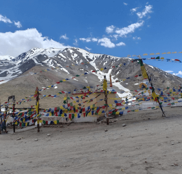
On the first day of their journey, they would begin their travel by road, and along the way, they would pass Rohtang Pass & Kunzum La. The trekkers would rest the day to get their bodies acclimatized to the high altitude. At Kunzum La, the trekkers could also visit the famous Kunzum Mata Mandir. As the trekkers drive from Kunzum La to Kaza, they will be enthralled by the beautiful Spiti River. When they reach Kaza, they would be welcomed by the key monasteries, and the trekkers could also explore the local market. Upon reaching Manali, they would be dropped off at the hotel by the Trekup India Representative, where they would be sleeping for the night.

Stay – Overnight stay at the guesthouse/hotel.
Meal – Breakfast, Lunch and Dinner
Distance – 18 km
Time Taken – approx. 50 min.
Altitude – Kaza (11,980 ft / 3650 mtr), Chicham (13,615 ft / 4150 mtr)
Altitude Difference – 1635 ft / 500 mtr
Trek Grade – By road
The trekkers would begin their day with a warm breakfast and prepare for the day ahead. The trekker would use this day to rest and get acclimatized by walking and exploring Kaza, like walking along the Spiti River and visiting Monasteries & Gompa. After they had explored Kaza, the trekker would begin the drive towards Chicham, a short drive.
Stay – Overnight stay at the guesthouse/hotel.
Meal – Breakfast, Lunch and Dinner
Altitude – 13,615 ft / 4150 mtr
The trekkers would begin their day with hot tea and the picture-perfect scenic views in front of their eyes. Chicham is famous for its suspension bridge, the highest in Asia. The trekkers would use this day to get their bodies acclimatized for the trek ahead. After the day’s excursion, the trekkers would return to the guest house or hotel and get ample sleep at night.
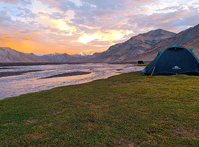
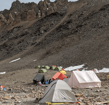
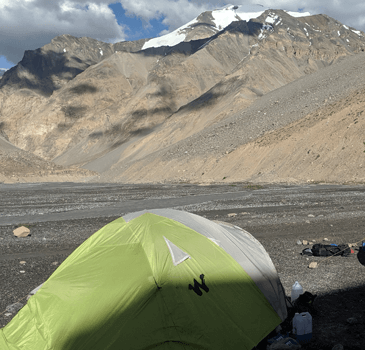
Stay – Overnight stay at the campsite.
Meal – Breakfast, Lunch and Dinner
Distance – 8 km
Time Taken – approx. 7 hrs
Altitude – Chicham (13,615 ft / 4150 mtr), Thaltak (15,387 ft / 4690 mtr)
Altitude Difference – 1772 ft / 540 mtr
Trek Grade – Gradual
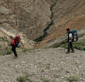
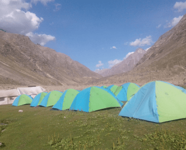
This day marks the first day of their trek, and the trekker would begin the day with hot tea. The trek from Chicahm would begin walking on the straight-led trail; the trekkers would soon start seeing the campsite at Dumla. Here, they would catch the water stream flowing in the middle of agriculture fields; from Dumla, the trail would begin ascending uphill with the view of Spiti mountains and zig-zag dirt trail, with locally grown vegetation of Tampa. As the trekkers reach Thalak, they would be enthralled by Kanamo Peak as it comes into view. Thaltak campsite has a fantastic idea with Kanmao peak in front and lush green meadows known as Thama bush. Rest for the night at the camp after the tiring day trek.
Stay – Overnight stay at the campsite.
Meal – Breakfast, Lunch and Dinner
Distance – 12 km
Time Taken – approx. 8 hrs
Altitude – Thaltak (15,387 ft / 4690 mtr), Borochin (16,732 ft / 5100 mtr)
Altitude Difference – 1345 ft / 410 mtr
Trek Grade – Gradual to Moderate
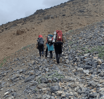
The trekkers would begin their morning with a delicious breakfast and prepare for the day’s trek. As the trekker starts walking from Thaltak meadows, the trail leads through a rough trail with deep gorges, loose gravel & rocks. The trekkers would then begin a downhill walk till they reach the riverbed of gushing river locally called Rong Nala. From there on, the trekkers would climb uphill till they reach Jukhta campsite, after which they will soon pass through the barren valley of Borochin. When they reach the Borochin campsite, they will see a small following stream. At this campsite, the trekker would get to sleep under the picturesque landscape of mountains studded with stars.
Stay – Overnight stay at the campsite.
Meal – Breakfast, Lunch and Dinner
Distance – 14 km
Time Taken – approx. 9 hrs
Altitude – Borochin (16,732 ft / 5100 mtr), Parang La Pass (18,370 ft / 5600 mtr), Kharsa Yongma (15,912 ft / 4850 mtr)
Altitude Difference – Borochin to Parang La Pass (1638 ft / 500 mtr), Parang La Pass to Kharsa Yongma (2458 ft / 750 mtr)
Trek Grade – Moderate to Difficult
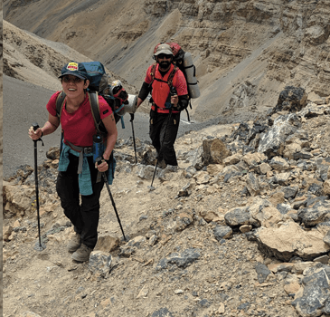
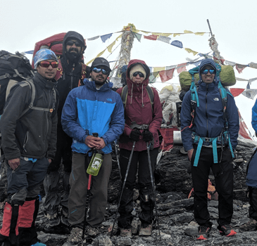
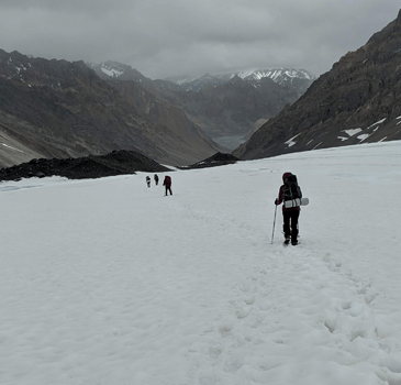
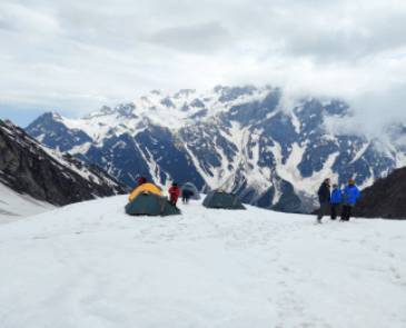
This day marks the primary day of the summit, where the trekker would be climbing the highest point of the trek. Trekup India Trek Leader will guide them and prepare them for the problematic level day trek, after which they will begin the trek through moraines. The trekkers would walk through the zig-zag trail until they reached Parang La. As the trekker reaches the top, they would be welcomed and spellbound by the view, which includes Spiti and Changthang valleys and Parilungi Peak.
.Once they have enjoyed the top picture, they begin their return trek, taking them to Parang La Glacier. As the trekkers reach Parang La glacier, they would walk past the glacier with the river flowing beneath. As they walk past the glacier, they must be extra careful as they pass through a few crevasses. The trekker would soon reach Lakku campsite; from there, it is just a few hours to the campsite, Kharsa Yongma. The trekkers would be sleeping at the camp, where they would hear the soothing sound of the river flowing and the fresh air of the mountains.
Stay – Overnight stay at the campsite.
Meal – Breakfast, Lunch and Dinner
Distance – 20 km
Time Taken – approx. 10 hrs
Altitude – Kharsa Yongma (15,912 ft / 4850 mtr), Kapapuche (15,420 ft / 4700 mtr)
Altitude Difference – 492 ft / 150 mtr
Trek Grade – Gradual
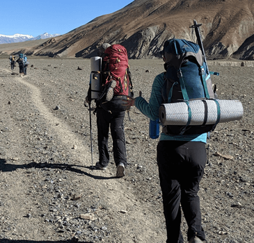
This day marks the descent and the return journey; the trekker will begin their trek after breakfast. The trail today will be leading through the riverbed, and they will be crossing numerous streams.
The route would also be passing through Datang Yongma & Datang Kongma, which are also the campsites. Catch a sight of Tsoma Nala flowing on the side of the Datang Yongma; on the way, they will also see Lasoma or Takli La Nala merging into Datang Nala after the Yongma campsite. After walking for some time, they would finally reach the camp at Kapapuche, where they would rest for the night.
Stay – Overnight stay at the campsite.
Meal – Breakfast, Lunch and Dinner Distance – 20 km
Time Taken – approx. 10 hrs
Altitude – Kapapuche (15,420 ft / 4700 mtr), Kitpodansa (14,930 ft / 4550 mtr)
Altitude Difference – 490 ft / 150 mtr
Trek Grade – Gradual to Moderate
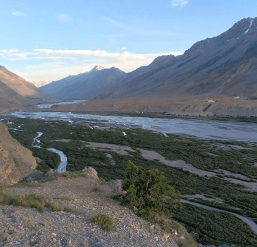
On this day, the trekker would walk on the trail like the previous day, but the altitude would be reduced. The trekker would be walking along the Pare River riverbed, catching sight of multiple streams or Nala, merging into the Pare Chu River and another merging into Falangbado Nala.
.
After walking for a while, the trekker soon reached Phalum Phada campsite, where they saw huge rock structures. Also, some small caves act as a reminder of the traders who used to find shelter in earlier times. The next place the trekker would be passing by Racholamo campsite, a merging point of 2 valleys; then the trekker crosses past Lakuk Nala, a major tributary river flowing near Racholamo campsite. After the day’s excursion, the trekker can rest at the camp and enjoy the scenic mountains. The next day, the trekker will ascend towards the mountain’s peak and take in the breathtaking views. After that, they will make their way back down and end the trek at the same campsite.
Stay – Overnight stay at the campsite.
Meal – Breakfast, Lunch and Dinner
Distance – 18 km
Time Taken – approx. 9 hrs
Altitude – Kitpodansa (14,930 ft / 4550 mtr), Chumik Shilde (15,420 ft / 4700 mtr)
Altitude Difference – 490 ft / 150 mtr
Trek Grade – Gradual to Moderate
Beginning the day, the trekker would wake up with a healthy breakfast and hot tea, and the trail would be downstream of the Parechu River.
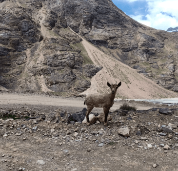
.The trekker will then pass Norbu Sumdo, and the route changes the landscape from riverbed to lush green meadows. Yellow flowers await on this trail; they would see wildlife such as Kiang (wild ass), a black wolf & Marmot. At the Chumik Shilde campsite, they would be enthralled by the green meadows and spring water. Have a good night’s sleep and take ample rest at night.
Stay – Overnight stay at the campsite.
Meal – Breakfast, Lunch and Dinner
Distance – 14 km
Time Taken – approx. 8 hrs
Altitude – Chumik Shilde (15,420 ft / 4700 mtr), Kingdom (15,060 ft / 4590 mtr)
Altitude Difference – 360 ft / 110 mtr
Trek Grade – Gradual
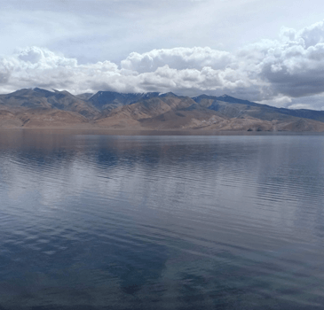
The trek would start on flat land and, through the dense green meadows, catch sight of the snow-covered peaks of the Mentok series.
As they walk ahead on the trail, they start seeing Tso Moriri Lake, which is a very pristine lake. As they reach the Kiangdom campsite, they might get to see wild asses, as the place is named after wild Tibetan asses, locally known as Kiangs. The lake is the nesting ground for many beautiful birds migrating to this region. After the trekker has trekked for the day, they would automatically sleep early.
Stay – Overnight stay at the guest house.
Meal – Breakfast, Lunch and Dinner
Distance – 21 km
Time Taken – approx. 9 hrs
Altitude – Kingdom (15,060 ft / 4590 mtr), Karzok (15,130 ft / 4610 mtr)
Altitude Difference – 70 ft / 20 mtr
Trek Grade – Gradual
This day marks the last day of the trek, and the trekker will enjoy the scenic views of the mountains one last time. The trekkers would begin the trek along the Tsomorir Lake on the side; they would get a beautiful view of Chamsher Kangri Peak and Lungser Kangri Peak. The trekkers would experience the changing colour of the lake depending on the time of day. The trail towards Karzok village will be uphill, and it will take a few hours to reach the campsite. Kazok village is a perfect example of solitude, with few houses and homestays.
Meal – Breakfast
Distance – 240 km
Time Taken – approx. 6 hrs
Altitude – Karzok (15,130 ft / 4610 mtr), Leh (11,562 ft / 3524 mtr)
Altitude Difference – 3568 ft / 1086 mtr
Trek Grade – By Road
On the last day of the trekkers’ journey, they would be driving through the mountains last time and taking in the serenity of the hills. They would be met by a Trekup India representative, who would then move them from Karzok to Leh. At Leh, the team would bid them farewell, and they would be on their own to explore Leh & the nearby area, or they could return home.
© 2024 All Rights Reserved - Mountains Heights